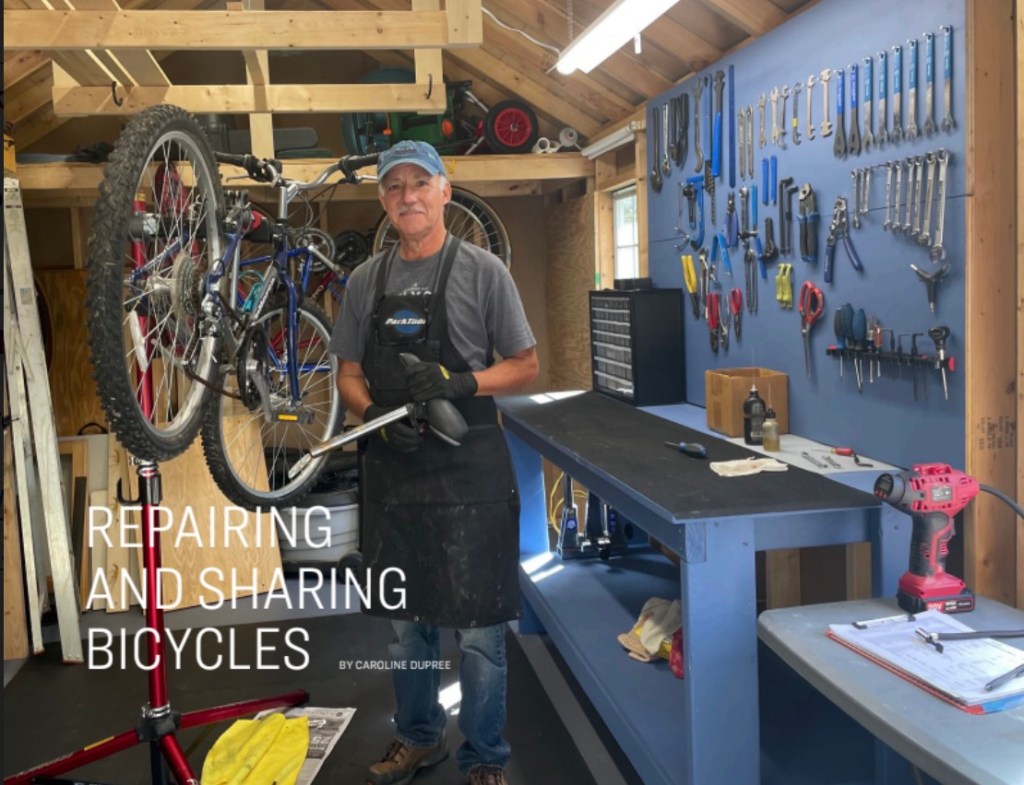
Manuel Vera in his bike workshop. Credit: Stroll Magazine
My Free Bikes Project is still going strong, with more than 420 bikes in the hands of new owners since 2020. If there are any bikes in the neighborhood that are outgrown or no longer used, I will refurbish them and pass them on to those who may not be able to buy one. Recently, I’ve been working with the International Rescue Committee and Homes Not Borders to give bikes to Afghan and African refugees settling in the community. Also needed are helmets, locks, and pumps. Neighbors can contact me at manvera@yahoo.com if they would like to donate these items.
You can read an article about the project that ran in Stroll magazine, a publication for residents in the community of Chevy Chase Village.
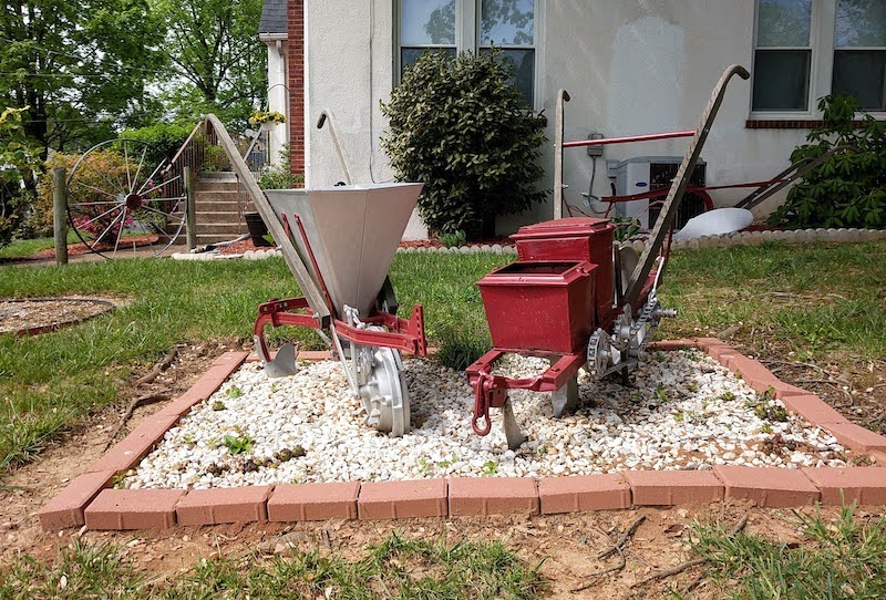
Most people zip past the intersection of Glen Ross Rd. and 2nd Ave., but there’s good reason to slow down and take notice of some interesting objects at the house on the northwest corner. Nancy Hope, who lives here with her husband, Ben, and their three daughters, grew up in that house.
On the lawn you’ll see farm implements, including a traditional plow, a horse-drawn corn planter, a fertilizer plow, a seeder, and a well pump, as well as wagon wheels and a windmill. (More about the latter below.) Nancy’s grandfather used them on the family farm in Pound, Virginia. Her dad, Grover Helton, brought them from the farm in the late 1970s after his father passed away.
During World War II, Grover served as an army medic. After moving to Silver Spring, he worked at Carriage Hill Nursing Home (now Regency Care of Silver Spring) on 2nd Ave. His wife, Charlotte, was also a nurse there, and they bought the house on Glen Ross to live close to their work.
Sadly, as is often the experience of immigrants and people considered “others,” Nancy’s family encountered hostility from neighbors who did not like the farm implements. They made unkind comments and left notes that “hillbillies should go back to the hills.” Had those neighbors gotten to know the Heltons, they would have discovered that Grover was a jazz-loving decorated WWII veteran. Although deeply hurt, the Helton family grew emboldened.
Nancy’s mother kept the notes as a reminder of the family’s “no-BS attitude:” Stand up for yourself, and remember that no one can tell you who you are—or what you can do. In defiance, her father added the windmill and wagon wheels as borders for flower beds.
Over the years, Ben has restored the farm implements, which he carefully and continually maintains. More than unique lawn décor, they represent a piece of family history that Nancy, Ben, and their children appreciate to this day.
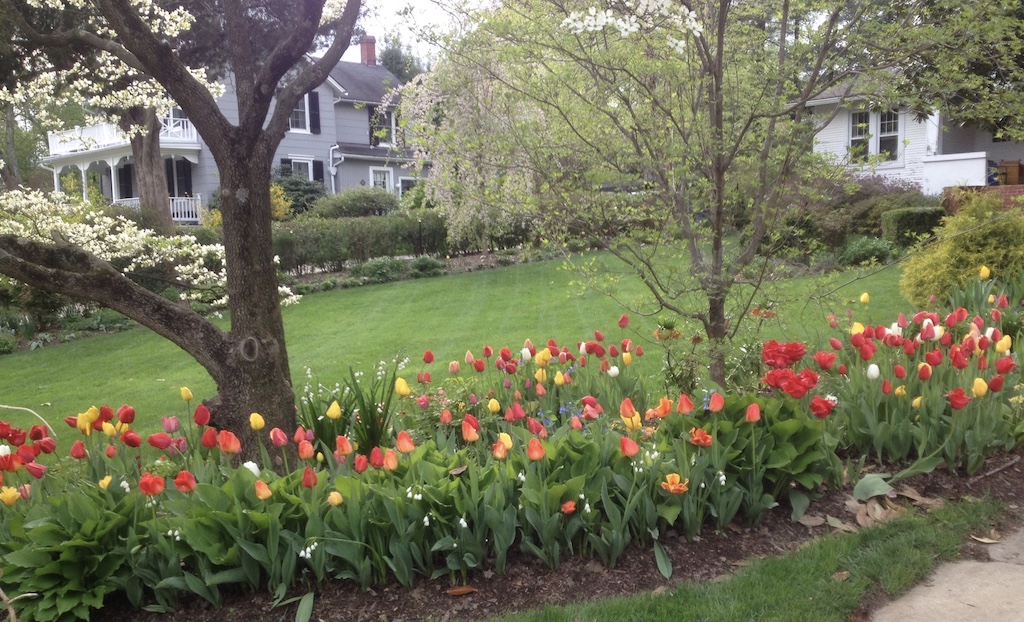
If you’ve ever strolled along Grace Church Rd. in the spring, you’ve probably seen colorful swaths of tulips blooming at the edges of the expansive lawn at 1923. Meet the man behind the tulips: Phil Costello has been planting them here every year since 2011. His interest in tulips took root when he lived in London: From his office near Buckingham Palace, he observed the planting of thousands of tulips. He also traveled frequently to Holland, where the flowers have been prized since the 16th century.
Phil starts planting his tulips in late November or after the first frost. He designs and digs trenches and places each bulb individually, this year about 750. (His all-time high is 2,100 bulbs!) Then he covers them with four to six inches of soil. Recently he has hired neighbors David Maya-Shelton and Jayden and Austin Jackson to help in the labor-intensive activity.
A major challenge is foiling predators, responsible for ruining up to 25 percent of the tulip garden. Squirrels dig up bulbs, but don’t seem to eat them. “They taunt me,” Phil laughs, “and then they throw away the bulbs,” leaving them on neighbors’ porches and in their yards. He places chicken wire over the bulbs to deter the pesky rodents and removes it so the tulips can grow when the weather warms. Deer don’t dig up the bulbs, but they do eat the blooms. “It’s constant effort,” says Phil, “vigilance is required.” He jokes that the deer of Grace Church may have changed their eating patterns after he placed signs directing them to a nearby street for better food.
Phil recommends purchasing tulip bulbs from colorblends.com. He also welcomes visitors to his garden. This writer has the advantage of seeing the vibrant flower display from her kitchen window, but you can take in the view come springtime. We’ll look for you on our street.
The NWCA Community Design Committee formed in early 2021. Our original discussions focused on the location of a memorial bench, but our goal was and remains to take a broader look at the use of neighborhood green spaces. We are interested in placemaking within the shared publicly owned pieces of land that are part of the fabric of North Woodside.
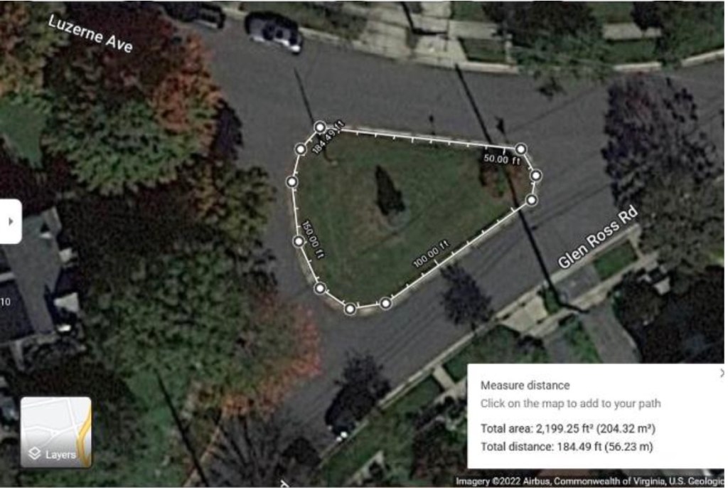
There are areas within our neighborhood that are imbued with memory as places for community interactions. One of these is the triangle at the intersection of Luzerne Ave. and Glen Ross Rd. where the community tree sits. It has served for decades as the place where neighbors come together to celebrate winter holidays. In the summer of 2020 it was where our youth called neighbors to action. And popular food trucks popped up alongside it in 2021. Alas, those moments, when the community injects the space with energy, are brief and few. The minimally maintained triangle is forgettable at best, and not many neighbors are drawn there during other times of the year. This place could be so much more than it is! At the urging of an adjacent neighbor, the Community Design Committee has begun to address this opportunity.
The land that we are referring to as the Community Tree Triangle is owned by Montgomery County and maintained by the Department of Transportation (MCDOT). Community Design Committee members have already been in communication with our assigned project contact (our county arborist) and a MCDOT traffic engineer. These officials appear very willing to approve NWCA’s efforts to improve the site. We’ve learned that permits will not be required, but county review of a design and coordination of its implementation are. We will maintain regular communications with the various county entities to ensure that improvements can move forward.
With the approval of the NWCA Board, members of the Community Design Committee solicited proposals for a master plan from three local women-owned landscape design firms. We met with each firm at the triangle and shared the following guidelines for the design:
Replace the grass with plantings of native species sourced from environmentally conscious growers and suppliers to attract pollinators and provide food and cover for birds. Consider the educational opportunity these types of plantings could offer the community.
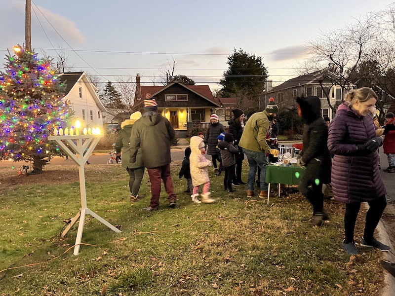
Maintain and possibly enhance the use of the area for the annual neighborhood holiday tree and menorah lighting events.
Consider features like stepstone pathways to invite the community to engage in the space.
Consider sight lines for traffic safety throughout the year.
Long-term maintenance should be minimal.
The NWCA Board voted to approve the proposal from Strawberry Fields
After careful review and input from the committee, the NWCA Board voted to approve the proposal from Strawberry Fields Design, LLC, to provide master plan landscape design services. Strawberry Fields was selected for its experience working with Montgomery County and on community projects of similar scope and scale and previous work in our neighborhood. Owner Kellie Cox is communicative, engaging, and knowledgeable. The board agreed to move forward with this investment in the design for a piece of land within our neighborhood because of the potential impacts on the community as a whole: visual, environmental, safety, and use.
Neighbors will be invited to engage in the design at key points in the process:
Prior to the landscape design work beginning, neighbors will be able to provide input via an online form and participate in a neighborhood meeting to chat with the designer, ask questions, and offer their ideas.
Once Strawberry Fields has developed a preliminary design plan, the Community Design Committee would share it with neighbors for further input at a meeting and/or via the neighborhood listserv and website.
It would also be shared with our county contacts for their review and input.
Strawberry Fields would take all the above input into consideration before finalizing a master plan.
The timeline for all of this will be sent out via the listserv in the coming months. We look forward to hearing what our neighbors would like to see happen with our shared space in the heart of our community!
The landscape master plan is a first step in making the Community Tree Triangle a more special place for our North Woodside community. Implementing that plan will require funding to turn drawings into plants and stepstones and flowers. At almost 2,200 square feet, this is a large area. The cost to achieve our goal is not yet known, but we can anticipate that it could be substantial. Rest assured that the Community Design Committee is already exploring ways to meet the challenge, such as grant opportunities, work parties, fundraising initiatives, and phasing the work to implement as funds become available.
Donations are always appreciated as an investment in our shared community design efforts. Interested neighbors may go to visit the NWCA donation page and follow instructions for contribution to the Neighborhood Beautification and Memorial Fund.
If discussions about the potential improvements to our neighborhood green spaces interest you, please join our Community Design Committee email list.
On December 18, 2022, neighbors gathered at the Community Tree Triangle for the 74th Annual Tree Lighting and 5th Annual Menorah Lighting and enjoyed hot cider and latkes. Photo by Phyllida Paterson
Amy Henchey cuts the ribbon at the dedication of the North Woodside Memorial Bench in honor of her late husband, Woody Brosnan. Photo by Ryland Owen
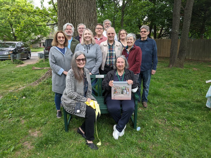
On May 1, 2022, the NWCA Board and Community Design Committee dedicated the first North Woodside Memorial Bench, in honor of longtime community volunteer, Woody Brosnan. The short ceremony, held in the “pocket park” at the intersection of Lanier Drive and 3rd Avenue, included a ribbon cutting by Mr. Brosnan’s wife, current North Woodside resident and NWCA Secretary Amy Henchey, plus memories of Mr. Brosnan’s dedication to local service by neighbor Gus Bauman.
If you would like to contribute to the cost of the bench you may make a donation to the NWCA’s new Neighborhood Beautification and Memorial Fund. To donate by check or PayPal, follow the directions on our NWCA Dues page.
NWCA President Genevieve McDowell Owen and NWCA Secretary and Woody Brosnan’s wife Amy Henchey sit on the first North Woodside Memorial Bench while other board members, Community Design Committee members, and neighbors pose behind. Photo by Anna White
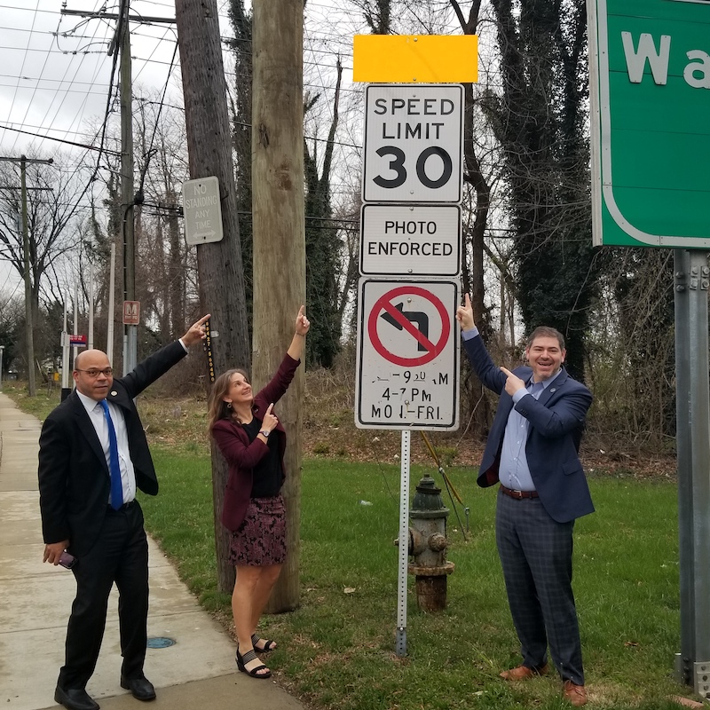
State delegates Al Carr, Lorig Charkoudian, and Jared Solomon point to the new speed limit sign on Georgia Ave. Photo by Michelle Desiderio Foster
The first of the long-awaited Georgia Ave. improvements in Montgomery Hills was implemented recently when the State Highway Administration (SHA) lowered the speed limit to 30 mph (from 35 mph) on Georgia Ave. from Spring St. to Wheaton. This speed limit was recommended in the Planning Department’s Montgomery Hills/Forest Glen Sector Plan adopted a few years ago. The speed reduction was just one of the significant improvements proposed for the corridor, including a green median, removal of the unsafe reversible lanes, wider sidewalks, a cycle track on the west side of the road, pedestrian-safety enhancements, a reconfigured Beltway interchange, and a new traffic light at Flora Lane.
A completed SHA design is expected by the end of 2022. Funding has been allocated for most of the necessary right-of-way acquisitions, and the county and state are cooperating to secure funds for utility relocation and construction. U.S. Senator Chris Van Hollen secured one million dollars in federal funding for the project in the recent infrastructure bill that Congress approved. Utility relocation could start as early as January 2024. State Delegates Jared Solomon and Lorig Charkoudian have worked tirelessly on this project to ensure that it continues to move forward and to secure necessary funding.
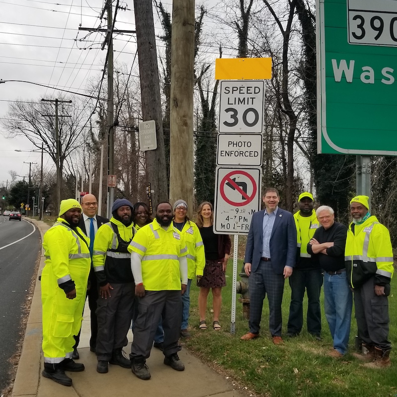
State delegates Al Carr, Lorig Charkoudian, Jared Solomon and State Highway Administration employees pose near the new speed limit sign on Georgia Ave. Photo by Michelle Desiderio Foster
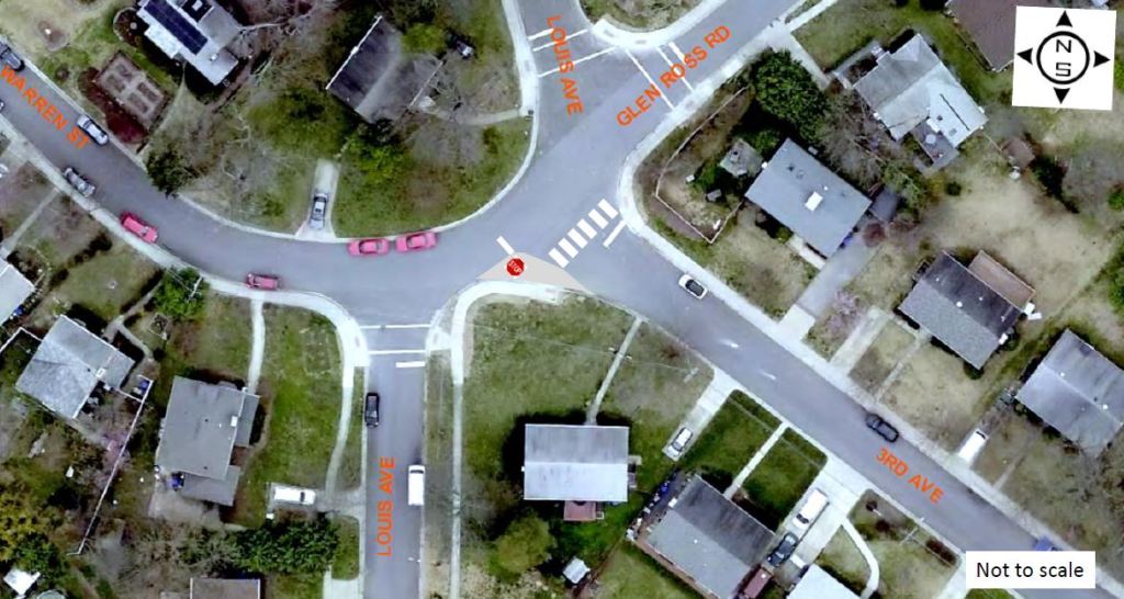
Adding a bump out and a stop sign will convert this intersection to an all-way stop. Image provided by Oscar Yen, MCDOT
The NWCA Traffic Committee and six neighbors met with Oscar Yen, an engineer in the Traffic Engineering Studies Section of the Montgomery County Department of Transportation (MCDOT), on April 13 to review pedestrian safety and traffic-calming measures at key neighborhood intersections.
Read on for highlights from his summary evaluation and recommendations, which include conducting a speed study on Luzerne near Louis and preparing a work order to add crosswalks with proper striping and/or stop-bar markings at the intersections listed below. (MCDOT will also perform another traffic study for all-way stop controls and other traffic-calming mitigations once Woodlin Elementary School and the Talbot Ave. bridge reopen and heavier traffic resumes.)
Louis and Luzerne Examine the feasibility of a curb bump out on Louis at the stop sign and trim foliage blocking the stop sign and the east leg approach of Luzerne.
Louis-Glen Ross-3rd-Warren Build a bump out at the southeast corner of the intersection of 3rd Ave. and Glen Ross Rd. to convert this intersection to an all-way stop control and address the no-stop condition for Warren St.
Luzerne-Louis-Lanier Create a bump out to reconfigure the intersection to a 90-degree T-shape, and possibly relocate the stop sign to increase its visibility.
Hanover and 3rd Readjust the crooked stop signs and research a more visible location for the sign on Hanover near the fire hydrant.
Grace Church and 3rd Add stop-bar street markings to help draw attention to existing stop signs, especially when foliage obscures them.
Talbot Ave. Bridge MCDOT will conduct a traffic study once the bridge reopens and evaluate for additional traffic-calming measures.
As you may know, the Maryland Legislature passed a law in 2020 to allow residents to file amendments to historic deeds to remove racially restrictive covenants from land records.
I had heard that some homeowners associations had successfully applied to have racist covenants stricken from their deeds as early as 2019. In November 2021, I contacted the Montgomery County State’s Attorney’s office for instructions on how to do this myself under the 2020 law. They sent me an intake form and instructions. I had already found the original deed to our house in the Maryland Land Records. The process took a little time to work my way back through the intervening deeds, which contained the relevant deed book/folio and page numbers to find the first deed from the Woodside Development Corporation to J. Reginald Boyd, the buyer who had our house built.
Once I found the deed, I was hoping it didn’t have a racially restrictive covenant, but alas it did. The 1925 deed provided, among other things, that:
“For the purpose of sanitation and health, neither the said party of the second part [buyer], nor their heirs or assigns shall or will sell or lease the said land to any one OF A RACE WHOSE DEATH RATE IS AT A HIGHER PERCENTAGE THAN THE WHITE RACE.” (Emphasis added)
I printed out the deed, crossed out the offensive covenant, filled out the State of Maryland Restrictive Covenant modification form, and took it to the Montgomery County Circuit Court, where a clerk took my documents, but issued no receipt or copy. Three months later I received my original signed and approved intake form and modified deed. Upon examination, it appears the county attorney approved the modification on January 18, 2022. I looked up the modification in the Maryland Land Records and found the modification online. All in all a fairly simple process after finding the deed. Also a satisfying personal endeavor that I’m happy to share with my neighbors across Georgia Ave.
Editor’s note: Ricky recently moved to nearby Woodside Park, after living on Hanover St. for 20 years. Many properties in North Woodside have similar racist deed covenants.
» Want to find out if your house has a racist deed covenant? You’ll need to do a chain of title search to dig up old deeds.
Enter the property address in the box at the top: A map identifying your property within its neighborhood context will appear.
Double-click within the boundary line of the property (zoom in first, if necessary), and a box showing basic property details will appear (owner, land use category, assessment date, year built, etc.).
Click on Data Description at the top of the box for a brief description of each piece of data listed; of most importance are the liber and folio numbers. This set of numbers constitutes the first deed in your chain of title.
Your next stop is the Maryland Land Records Database. You’ll need to submit a request for an account before you can access the database. Once you have your account and the liber and folio number for your property’s current deed, you can begin searching. It’s always best to start with the current deed, even if you’ve identified previous deed information.
Select your county (Montgomery) from the upper-left drop-down menu.
On the search page that opens, search using the top box, titled “Jump to New Volume,” searching via liber and folio numbers.
Skipping the Clerk box, enter your liber number in the Book box and your folio number in the Page box.
The deed document that opens will be the current deed for your property, which should list the current owners as the grantees (buyers), along with the grantors (sellers). It will provide the date of the property transfer and a description of the property, often including the lot number, block number, subdivision name, and the location within Montgomery County Land Records of the document recording the original platting of the subdivision within which it is located. (For example, “…the west 50 feet in width of Lot No. 3, in Block No. 20 by the full depth of 150 feet, in the subdivision of land known as and called B.F. Leighton’s Addition to Woodside, as per plat recorded in Plat Book A, Plat No. 60.”)
With this information, you can visit plats.net. Start by selecting Montgomery County in the drop-down menu, and when the Basic Search box appears, enter the plat book number and plat number in the appropriate boxes. You should see the name of the appropriate subdivision and a hyperlink to an MSA (Maryland State Archives) accession number. Click on this link, and you will be taken to the original platting record of the subdivision (usually a map of the subdivision) within which your property resides.
At this point you know the starting point (current deed) and ending point (subdivision platting) of your chain of title, but you must fill in all the deeds in-between. To do this, return to mdlandrec.net and begin working your way backward from the current deed.
In the current deed, somewhere below the property description, there may be a paragraph that notes the liber and folio number of the previous deed. If so, return to the search page and enter this information, and continue following this process until you reach a deed that does not list the previous deed’s information. Unfortunately, this may happen at almost any point in the chain of title search.
When this happens, return to the main Montgomery County Land Records Indices page.
If the oldest deed you locate is from 1977 or later, click on “Individual Search” or “Corporation Search” in the left-hand column. This is a straightforward search process that involves entering the name in question and the date parameters.
If the oldest deed you locate is from 1976 or earlier, click on “Active Indices” in the column on the left. Since the grantee name is the only name you know at this point (i.e., the grantor on the oldest deed you’ve located), click on “Land Records, Grantee Index, 1777–1976” in the drop-down menu. Then choose which block of dates you want to search within. Begin with the most recent block of possible dates for the deed you’re searching for; for example, if your earliest known deed is dated March 5, 1975, begin with the indices from 1973–1977. Under this block of dates, look for the first letter of the owner’s surname, or corporation name, and then the first letter of their given name. Once this page opens, click on the red hyperlink on the right — “How to Use Montgomery County Land Record Indices” — for an overview of the process used to continue your search from here. Once you find the next-oldest deed, the previous deed’s liber and folio numbers may be listed here, but if not, repeat the process of using the Active Indices search option (or Individual/Corporation search, if it’s still later than 1977) to continue to work backward. You’ll know you’ve reached the end of your chain of title when you locate the deed in which the name of the grantor is the individual or corporation that platted the subdivision in question.
The most user-friendly source of historic newspapers is the Library of Congress website “Chronicling America” (chroniclingamerica.loc.gov), which provides free access to a searchable network of digitized newspapers from across the country. The Advanced Search tab allows you to select a specific state, or the District of Columbia, to search within, and gives you multiple options for key word searches.
For Montgomery County, it is always a good idea to try each search in both Maryland and the District of Columbia. The “Evening Star” (Washington, D.C.) was considered the newspaper of record for many decades, and it is also a wonderful source of social news for the city and the surrounding counties. The “Montgomery County Sentinel” is another important local newspaper in the database.
Editor’s note: If you would like to be part of an organized approach to neighborhood history research — or if you come across any interesting information related to neighborhood history that you’d be willing to share with neighbors — contact the North Woodside History Group.