By Cheryl Copeland, Community Design Committee
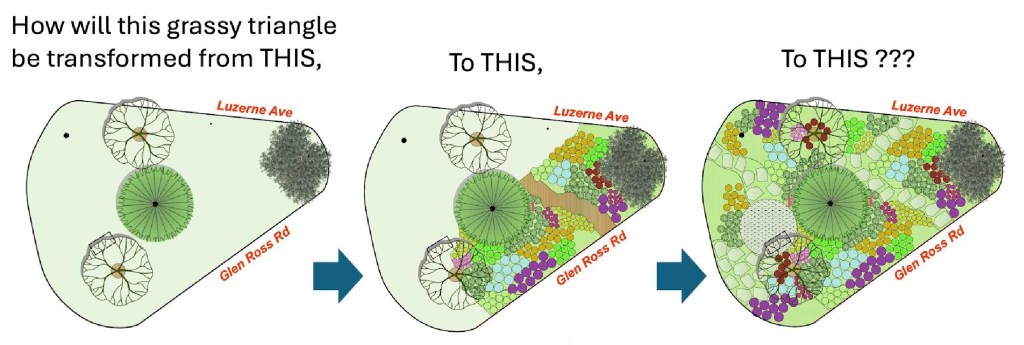
Have you seen the two new flowering trees keeping our community evergreen tree company on the grassy island where Luzerne and Glen Ross merge east of 2nd Avenue? These are just the first signs of exciting things to come to this location!
The Chesapeake Bay Trust recently awarded NWCA their Community Engagement & Restoration Mini Grant ($5,000) to put toward some of the landscaping in the master plan designed by Strawberry Fields, LLC in 2023, to be installed this fall.
The community tree triangle project is not simply to beautify a space enjoyed by a handful of neighbors and the occasional passerby. The Chesapeake Bay Trust awarded us this grant for “community engagement and restoration” because this space has a 100-year history within the neighborhood as a gathering place, which will provide educational opportunities, environmental benefits, and encourage year-round use by the greater community.
The full plan is to replace all the grass with a variety of primarily native perennials in amended soil, stepstone paths, and a circular river-stone patio. Grant terms include a commitment to include educational signage and provide workshops for neighbors and youth groups at the triangle and to teach about the sustainability of this type of conservation gardening using native plants to support pollinators in a way that is both sustainable and easily replicated in their own yards.
The estimated cost for this work is more than the grant received, so the Community Design Committee continues to pursue other funding options. This June we will learn the decision for the fourth and final Chesapeake Bay Trust grant we have applied for since 2024. The house tour event taking place this September is intended to help pay for any portions of the community tree triangle project not funded by grants.
At the upcoming NWCA Annual Meeting, we will have a table to present the project details and answer questions. The NWCA Board will recommend a dollar amount for the project, but it will require a membership vote. We hope as many community members as possible will attend the meeting to engage in the conversation before approving how much funding our association will provide.
The tree triangle project is what the Community Design Committee was formed to do — explore good and thoughtful design that engages our community at large. If that piques your interest, join us by subscribing to our listserv communitydesign+subscribe@NorthWoodsideCA.groups.io (subscription to main neighborhood listserv required).
When we gather as a community at the triangle this December to celebrate the 100th anniversary of North Woodside’s holiday celebrations, we’ll look forward to unveiling the next chapter in the story of our community tree triangle!
Learn more about our native garden project at the NWCA Annual Meeting on May 20, 2026
Help us raise funds to complete the full project by supporting the North Woodside House Tour on September 26, 2026. Buy tickets, volunteer, and/or sponsor! For more information, click here.